
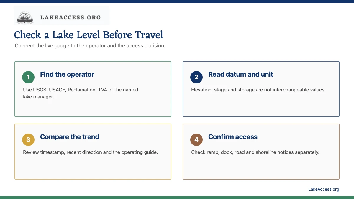
Quick answer: Find the agency that operates or gauges the lake, open its current elevation, stage or storage record, and read the timestamp, unit and datum before comparing values. Then check the recent trend, releases and the exact ramp or dock notice. A lake level alone does not prove that an access point is open or navigable. Save the operator contact and a second legal access before towing a boat. Recheck both sources immediately on departure day and after any overnight storm or release.
What to read before making a decision
| Signal | What it can tell you | What it cannot prove | Next check |
|---|---|---|---|
| Elevation or stage | The water-surface height relative to a stated datum | Depth at every ramp, dock, channel or shoreline | Datum, units, station location, timestamp and access notice |
| Storage or percent capacity | Reservoir volume under the operator's method | A direct shoreline height or usable ramp depth | Capacity definition, conservation pool and operator notes |
| Recent trend | Whether the reported value has risen or fallen over the selected period | The cause or the next operating decision | Rain, inflow, releases, forecast and operating guide |
| Ramp or facility notice | Whether the managing agency reports an access restriction | Safe navigation outside the inspected facility | Current closure, lane condition, dock status and posted signs |
Find the operator before searching for a number
USGS provides lake and reservoir gauges, USACE publishes water-control data for its projects, Reclamation publishes reservoir conditions in western basins, and TVA provides current levels and operating information for its system. State agencies, utilities and local operators cover many other lakes. Start with the named operator so the measurement and access guidance refer to the same project.
Save the lake name, project, station ID and map position. A downstream river gauge, weather-app lake card or third-party chart may not describe the pool. If multiple agencies publish data, identify the original source and use the operator for release schedules, operating guides and facility notices.
Do not mix elevation, stage, depth and storage
Elevation is a water-surface height relative to a vertical datum. Stage is a gauge-height measurement defined for the station. Storage is volume, often reported in acre-feet or as a percentage under an operator-specific capacity definition. None is automatically the depth at a ramp or dock. Read the label, unit and datum before comparing values or years.
A normal or conservation pool is an operating reference, not a promise that the lake stays fixed. Flood-control pools, seasonal drawdowns, hydropower operations, water supply and drought plans can change the target. Use the current operating guide and notes rather than treating one reference elevation as a universal safe level.
Read the trend and operations together
Open at least several days of data and note whether the level is rising, falling or stable. Then check inflow, release or generation information when the operator provides it. A similar level can produce different shoreline or current conditions depending on the direction and rate of change.
Timestamps and provisional labels matter. Some dashboards have routine update windows or temporary gaps. Do not interpolate a missing current value without saying it is an estimate. If releases, flooding or rapid change could affect the trip, use the operator's current notice and weather or emergency guidance.
Verify the exact ramp, dock and route separately
A reported pool elevation does not show sediment, a damaged lane, an exposed hazard, construction, road access, parking or a local closure. Open the managing agency's facility page or call the office. Ask about the exact ramp, usable lanes, dock position, low-water restrictions and trailer access.
On arrival, follow signs and inspect from a safe staging area. Do not walk into a launch lane or drive onto an exposed lakebed to test access. Water levels can reveal hazards that were previously submerged, and an old contour or satellite image is not a current navigation chart. Keep a backup access point and enough margin to leave before conditions worsen.
Work a level check from national source to local decision
Suppose a reservoir page reports a current elevation and a falling three-day trend. First confirm the gauge timestamp, datum and operator. Next open the operating guide or release page to see whether the decline is expected. Then open the exact park or ramp page and look for lane, dock or road restrictions. Finally, call the facility when the notice does not connect a usable ramp to a stated elevation.
The conclusion should describe only the evidence found: for example, the pool was falling at the reported station and the operator listed one ramp as open at the time checked. Do not convert that into a claim about every cove, shoreline or navigation route. Save the time of each source because the gauge and facility notice may update on different schedules. If towing a boat, record the facility contact, planned arrival window, backup ramp and route home. Repeat the level and closure checks before departure because an overnight release, storm or maintenance notice can invalidate the earlier plan.
Start with the agency that owns the decision
A search result, weather app, marina post or crowd-sourced map can help locate a data source, but it does not issue the rule for a lake. Identify the agency that operates the reservoir, samples the beach, manages the park or publishes the health notice. The responsible organization may be a state environmental or health department, a Tribe, county health office, city beach manager, federal reservoir operator or utility. Save the exact page and the agency name with the trip plan.
Jurisdiction matters because two access points on the same water can use different monitoring programs or notices. A federal gauge may describe elevation while a county notice controls swimming at one beach. A park closure can remain in effect even when a regional dashboard looks normal. When sources disagree, follow the most current instruction from the agency responsible for the exact activity and location, and contact that agency rather than averaging the answers.
Read the timestamp before the value
Live data is only live relative to its collection and publication time. Find the observation time, time zone, update frequency and any provisional-data label. A dashboard opened today can display a sample collected several days earlier. Automated stations can also stop reporting, retain a last value or publish a quality-control flag. Record the timestamp in the same note as the value so it cannot be separated from its age.
Think about what could have changed since the measurement. Rain, wind, heat, inflow, dam operations, a sewage release, a bloom, heavy use or a sensor problem can alter conditions. A trend can be more useful than one point, but a trend still does not override an active advisory or on-site sign. Refresh the official page shortly before departure and again when practical on the trip day.
Match the station to the exact place
Similar lake names, multiple basins and distant stations are common sources of error. Confirm the waterbody, state, county, station identifier and map position. On a large lake, a main-channel buoy may not represent a shallow cove, tributary beach or protected marina. A downstream river gauge may respond differently from the reservoir pool. Save a second source or station when the first one is not clearly connected to the destination.
Also read the sampling depth and method. A surface temperature, a probe one meter below a buoy and a deep profile are different observations. A bacteria sample at a designated beach answers a narrower question than a watershed nutrient assessment. A gauge elevation describes a reference surface, not the depth at every dock or ramp. Use the measurement only for the question its location and method can support.
Separate observation, model, forecast and notice
An observation records what a sensor or sample measured. A model estimates conditions between observations. A forecast projects future conditions. An advisory or closure tells the public what action the responsible agency recommends or requires. Each can be useful, but they are not interchangeable. Label them in your notes and avoid presenting a modeled map as a field measurement or a measurement as a safety clearance.
Provisional readings may change after review, and a forecast includes uncertainty. A notice can also remain active while resampling is underway. Look for quality flags, explanatory notes and the latest agency update. If the source does not explain whether a value is observed, modeled or forecast, do not build a high-risk decision around it.
Use thresholds only for the activity and jurisdiction named
Water-quality criteria, recreational advisories, reservoir operating bands and local access rules are written for particular uses. A value acceptable for one purpose may not answer whether swimming, drinking, fishing, paddling or launching is appropriate. Units and averaging periods matter too. Do not compare a single sample with a multi-sample criterion, or copy a threshold from another state, Tribe or program without confirming that it applies.
The safest workflow is to let the issuing agency interpret its own program. Read the current notice, definitions and required action. If the threshold or status is unclear, treat the uncertainty as unresolved. This guide teaches how to locate and read public data; it does not certify a lake, diagnose an exposure or replace health, emergency, navigation or engineering advice.
Check conditions at the access point
Online data should lead to an on-site verification, not replace it. Read posted signs, look for barriers or staff instructions and confirm the exact ramp, beach, trail or dock remains open. Leave when an official closure, severe weather, unsafe water appearance, damaged infrastructure or another hazard conflicts with the plan. Do not enter restricted areas to inspect a sensor or obtain a closer photograph.
Keep people and pets away from discolored, scummy or foul-smelling water, and follow local health guidance. Never taste water or handle a suspicious bloom to test it. A clear appearance is not proof that water is safe, and an unusual color is not a laboratory result. Use visual conditions as a reason to pause and seek current official information.
Save an offline trip record
Before leaving reliable service, save the source URL, agency phone number, station or beach name, timestamp, screenshot or downloaded report, and the decision it supports. Include a backup destination. A small record makes it easier to notice when two sources refer to different places or times, and it helps explain why a trip plan changed.
Do not rely on a screenshot alone when the status may change. Refresh the source when connectivity returns and keep emergency alerts enabled. For repeated visits, compare records over time while preserving units and datum. The goal is a repeatable verification habit, not a permanent claim that a lake always behaves the same way.
Trip-day checklist
- Identify the lake operator and original gauge.
- Save station, datum, units, timestamp and provisional status.
- Compare recent trend with releases and the operating guide.
- Check the exact ramp, dock, road and facility notice.
- Inspect posted conditions safely and keep a backup access point.
Related LakeAccess guides
- Boat ramp checklist for first-time boaters
- How to find public lake access
- Great Lakes water levels guide
- How to find lake water temperature data
Sources
Monitoring methods, notices and operating data can change. These official or high-trust sources were checked July 18, 2026; open them again for the trip date.
- USGS Water Data for the Nation (checked July 18, 2026)
- USGS National Water Dashboard (checked July 18, 2026)
- USACE water data (checked July 18, 2026)
- Bureau of Reclamation reservoir conditions (checked July 18, 2026)
- TVA lake levels (checked July 18, 2026)
- USGS lakes and reservoirs (checked July 18, 2026)