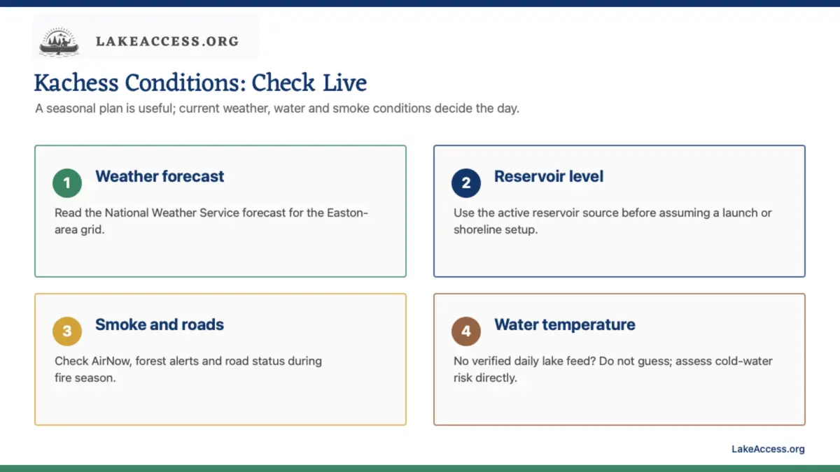
Quick answer: Lake Kachess conditions change with mountain weather and reservoir operations, so use seasonal climate normals only as planning context. The nearby high-elevation NOAA Stampede Pass station has 1991–2020 monthly mean air temperatures ranging from 28.1°F in December to 60.0°F in August; its July normal is 68.2°F for the average high and 49.6°F for the average low. Those are air normals at a nearby high-elevation station, not Lake Kachess water temperatures. We did not identify a verified public daily Lake Kachess water-temperature feed, so do not invent one: check the live forecast, reservoir/access information, smoke and road alerts, and assess cold-water risk on arrival.
Use climate normals correctly
NOAA climate normals are long-term reference values, not a forecast. The table below uses the 1991–2020 NCEI monthly normals for Stampede Pass, a nearby high-elevation station. The NCEI file reports varying years of record by month and measure, so this is a location-specific planning proxy, not a 30-year Lake Kachess water record. Lake elevation, shade, wind, snowpack, and reservoir operation can make your actual conditions different.
| Month | Nearby normal high | Nearby normal low | Planning implication |
|---|---|---|---|
| January | 32.4°F | 24.8°F | Winter access and snow conditions need a dedicated check. |
| February | 34.7°F | 26.0°F | Plan for winter travel conditions rather than water recreation. |
| March | 40.2°F | 29.0°F | Conditions can remain wintry at elevation. |
| April | 45.7°F | 32.7°F | Check roads, trails, and changing reservoir conditions. |
| May | 53.4°F | 38.4°F | Layering and a water-access check remain important. |
| June | 59.6°F | 43.3°F | Use the live forecast and do not assume warm water. |
| July | 68.2°F | 49.6°F | Warm air can still coincide with cold reservoir water. |
| August | 69.0°F | 51.0°F | Check drawdown, smoke, and late-season launch access. |
| September | 62.7°F | 46.7°F | Shorter days and cooler nights change the margin for error. |
| October | 49.3°F | 37.8°F | Shift toward fall weather and road-condition planning. |
| November | 37.8°F | 29.5°F | Winter travel and facility availability can dominate the plan. |
| December | 31.9°F | 24.3°F | Use winter-specific sources before traveling. |
Water temperature: the responsible answer
Search results and travel pages often supply a confident water-temperature range without naming a measurement site, depth, time, or method. That is not sufficient for a safety decision. The official sources consulted for this article confirm the reservoir, access, recreation, and weather context, but they do not publish a verified daily Lake Kachess surface-temperature value. This guide therefore does not claim a seasonal water-temperature range.
For swimming, paddling, or a boat emergency plan, assume mountain-reservoir water may be cold enough to affect breathing and movement even when the air is pleasant. Wear a life jacket for boating, keep the first swim conservative, avoid diving into unknown conditions, and choose shore activity when your group cannot manage the water safely.
Weather: use the official grid forecast on the day
The National Weather Service forecast point near Lake Kachess resolves to the Easton, Washington, area. On July 10, 2026, that official forecast showed a sunny Friday near 74°F with light west wind and an overnight low near 51°F; that is a same-day weather observation, not a seasonal promise. Open the current NWS point forecast before travel and again when a forecast update could change your plan.
Look beyond the daytime high. Wind matters on open water; overnight temperature matters for camping; and thunderstorms, visibility, rain, or smoke can change the safe activity. Forecast uncertainty is a reason to shorten exposure and keep a backup, not to dismiss the source.
Reservoir levels and access
Kachess is a Bureau of Reclamation reservoir used for Yakima Basin irrigation storage. Reclamation’s recreation analysis says the reservoir is generally fullest in spring and early summer and reaches its lowest levels in late summer; it also notes that boat-launch operation depends on water levels. WDFW repeats the practical result: excessive late-summer drawdown can leave no boat-launching facility available. Use the Kachess Dam page and USGS monitoring page as live-reference starting points, then make the final access decision onsite.
Water level is not merely a boating fact. A changed shoreline can alter the distance to water, footing, launch geometry, and the experience of a designated recreation area. Do not predict an August trip from a June photograph.
Smoke, fire, roads, and seasonal closures
During fire season, check Forest Service alerts, local road information, and AirNow before you leave. Smoke can reduce air quality and visibility even when a recreation site is technically open. For winter, use Washington State Parks and forest sources for Sno-Park, road, and snow conditions rather than assuming that a summer route is open. Kachess Sno-Park is a winter-specific facility and should not be used to infer summer campground conditions.
A season-by-season decision checklist
- Winter and early spring: start with road, snow, and closure status; do not build the day around water access.
- Late spring and early summer: check the live weather and reservoir context; do not mistake a filling pattern for a launch guarantee.
- Mid-summer: check wind, heat, fire/smoke, water appearance, and the exact facility notice before swimming or boating.
- Late summer and fall: recheck water level and access because drawdown may change shore and launch options.
Useful LakeAccess planning links
- Lake Kachess boat launch guide.
- Lake Kachess fishing guide.
- Can you swim in Lake Kachess?
- Things to do near Lake Kachess.
- How to know if a lake is safe to swim in.
Why nearby air normals are useful but limited
Stampede Pass is near Lake Kachess but it is not the lake. Its elevation, exposure, and station history differ from the campground and shoreline. The table is useful because it anchors planning in an official, named dataset instead of vague seasonal language. It is limited because it cannot predict the temperature in a shaded campsite, on a windy boat, or in the reservoir itself.
Read the table as a packing and expectation tool. Colder normal nights support warmer layers and a more conservative overnight plan. A relatively warm normal afternoon supports sun and hydration preparation, not an assumption that the water is warm or that smoke, wind, and access will cooperate.
Build a live-source routine
- The evening before: read the official facility page, forest alerts, and general forecast.
- The morning of travel: refresh the forecast, check smoke and road conditions, and review reservoir/access context.
- At the site: read posted notices, look at the water and wind, and decide whether the original activity remains sensible.
- Before entering the water or launching: use the group’s skills, gear, daylight, and return plan as a final filter.
This routine is deliberately repeatable. It avoids the false choice between ignoring weather entirely and attempting to forecast a specific lake from a single old climate average.
Pack for conditions, not calendar labels
In every season, bring layers that can handle an unexpected temperature drop, rain protection, sun protection, drinking water, and a way to get dry. Add cold-weather and traction equipment when winter sources require it. During fire season, include a smoke-aware backup and be prepared to leave if air quality or visibility changes. For water activities, a life jacket and conservative exposure plan belong in every season.
Do not leave food, fuel, or waste vulnerable to wildlife, and do not build a fire unless current restrictions and the designated facility allow it. Conditions can be pleasant while a restriction remains in force.
Read the monthly table as a range of preparation
July and August have the warmest nearby normal air temperatures in the table, but their normal lows remain around 50°F. That is enough to make warm layers relevant after sunset even when daytime air feels comfortable. October through April normals reinforce that cold-weather readiness and route checks are central to the trip, not an afterthought. The exact experience at the lake may be warmer, colder, windier, or wetter than the nearby reference.
Use the normal high and low to decide what belongs in the vehicle, then use the live forecast to decide whether the activity belongs in the day. This distinction prevents a planning table from becoming an unearned forecast.
Why reservoir water does not follow air temperature
Water warms and cools differently from air, and reservoir conditions vary by location, depth, inflow, wind, shade, and operations. A sunny afternoon does not provide a measured water temperature. That is why this page distinguishes a documented nearby air normal from an unverified lake-temperature claim. The correct response to uncertainty is a cautious entry and a short exposure plan, not a number with no source.
For any boat or paddle plan, cold-water awareness remains relevant throughout the season. Wear a life jacket, protect against wind, and maintain a return margin. For swimming, keep the entry gradual and stay close to shore when you do not have verified conditions.
Keep the sources current
Bookmark the facility page, NWS point forecast, reservoir/monitoring sources, forest alerts, and AirNow before a trip. Refresh them on the morning of travel. The purpose is not to produce a perfect prediction; it is to identify the changes that should alter the activity, the route, or the decision to stay home.
This page should be revisited quarterly and whenever an official source changes. It is designed to point readers toward live evidence rather than to become a stale substitute for it.
Seasonal planning summary
Use winter sources for access, spring sources for changing roads and water, summer sources for heat, wind, smoke, and water recreation, and late-season sources for drawdown and shorter days. The live check remains the same in every month: facility, forecast, conditions, and a route home.
Sources
- NOAA NCEI: U.S. Climate Normals methodology (checked July 10, 2026).
- NOAA NCEI: Stampede Pass, WA monthly climate normals (checked July 10, 2026).
- National Weather Service forecast point near Lake Kachess (checked July 10, 2026).
- Bureau of Reclamation: Kachess Dam (checked July 10, 2026).
- USGS Water Data: Kachess Lake Near Easton (checked July 10, 2026).
- Washington Department of Fish and Wildlife: Kachess Lake (checked July 10, 2026).
- AirNow (checked July 10, 2026).